


Land & Hydrographic Surveys: Chartered Surveyors
Aspect Land & Hydrographic Surveys Ltd is an established company of chartered surveyors, with over 20 years of experience utilising the latest innovations in survey equipment and technology, providing a full range of survey services throughout the UK and abroad.
We produce work to the highest quality, endorsed by our accreditation to numerous organisations including the Royal Institute of Chartered Surveyors, the Chartered Institute of Civil Engineering Surveyors and The Hydrographic Society. All of our practices and procedures are governed by RICS regulations.
The quality of our service is further underpinned by our accreditation to the ISO PAS99 and Achilles UVDB standards, incorporating Quality, Environmental and Health & Safety certification.
Our approach is to fully engage with our clients from the outset, utilising our experience and expertise across the full range of survey disciplines, to ensure that we have a thorough understanding of their requirements, allowing us to manage their expectations and to advise on the most appropriate methodologies, optimising value for money. This ensures that our clients receive a professional service tailored to their individual requirements.
Whatever the challenge,
we have the solution.
LATEST NEWS

Constructionline Gold & Acclaim Accreditation
Aspect Land & Hydrographic Surveys Ltd has recently been awarded Constructionline Gold L3 Accreditation, demonstrating the company’s long-standing commitment [...]

Covid-19 Update
During such uncertain times, we want to assure clients that Aspect Land & Hydrographic Surveys Ltd is committed to supporting [...]

First Exhibitor Afloat for M&CCE Expo 2019
‘Offshore Sensor’ is a multi-purpose MCA Cat I survey vessel, ideally suited to works associated with demanding offshore operations. The [...]
FEATURED PROJECTS

3D Railway Bridge Survey
A 170-year-old bridge has been demolished, having been found to be in such a poor state it had been deemed a “danger” to the [...]

Sunderland Breakwater
The historical masonry Old North Pier at Sunderland was damaged during severe storms in March 2018. Outline repair schemes have been developed but to [...]

Join The Team
Aspect Land & Hydrographic Surveys Ltd have a number of recruitment opportunities for qualified personnel to join our team of professional surveyors. We are an [...]
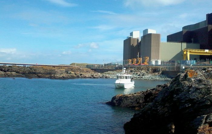
UXO Works at Wylfa Power Station
Aspect Land & Hydrographic Surveys Ltd were contracted to undertake a multibeam, side-scan and magnetometer survey as part of a larger UXO (Unexploded Ordnance) project [...]

Aspect Make Business Awards Final
The short list for the Ayrshire Chamber of Commerce’ Business Awards 2017 has been unveiled, and first time entrants Aspect Land & Hydrographic Surveys have [...]

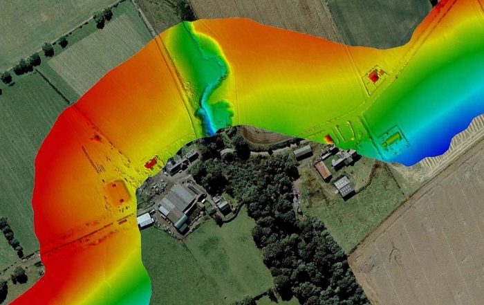
Aspect Support KOSWF Project
Aspect Land & Hydrographic Surveys Ltd has recently completed a nearshore survey contract to support the hydrographic survey schedule at the site of the proposed [...]

M&CCE Expo 2018
Marine & Coastal Civil Engineering 2018 Aspect Land & Hydrographic Survey Ltd will be exhibiting at M&CCE, the UK’s leading civil and structural engineering event [...]

Aspect Assist Carrier Launch
Aspect Land & Hydrographic Surveys Ltd provided a campaign of dredge support surveys to both UK Dredging and Babcock International Group in readiness for the [...]
Aspect complete 12km LiDAR route survey
As part of an ongoing framework agreement to provide topographic and associated survey services, Aspect Land & Hydrographic Surveys Ltd were appointed to provide data [...]
